
Google Maps Features I Didn’t Know Existed Until Last Year
I’ve been using Google Maps almost every day for years and still managed to miss features that were sitting in my settings the whole time. Some I found by accident. A couple I found because someone mentioned them offhand and I felt slightly embarrassed that I’d been doing things the slow way for so long. A few are genuinely new, part of what Google is calling the biggest Maps update in over a decade, rolled out through early 2026. Either way, I use the app differently now, and writing this is partly just me wishing I’d known about most of it sooner.
Glanceable Directions
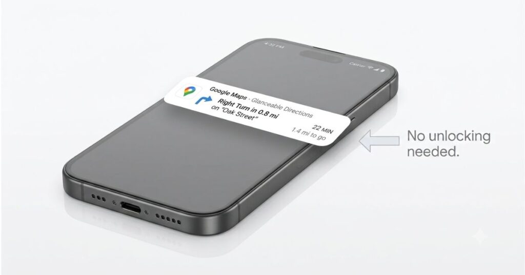
This one annoyed me for longer than I want to admit before I found out it existed. Every time I started navigating somewhere I’d put my phone in the car holder, and then five minutes later have to pick it up, unlock it, and open the app again just to check my ETA or see what was coming. That’s the whole thing the feature fixes.
Glanceable Directions shows your next turn and updated ETA right on your lock screen while you’re moving. No unlocking. No reopening the app. It’s been available on both Android and iPhone for a while but it’s off by default, which I think is the only reason most people don’t know it’s there. To turn it on: tap your profile picture, go into Settings, then Navigation, then switch on Glanceable Directions. That’s genuinely it. It also works in walking and cycling mode, not just driving, which I didn’t expect.
Saving Your Parking Spot
I spent fifteen minutes wandering around a car park after a film once, clicking my keys, no idea which level I’d left the car on. I found out afterward that Google Maps has been able to save your parking spot for years. Years. I just never knew.
After navigation ends from a drive, tap the blue dot on the map and there’s an option to save your parking location. It drops a pin right where you are. You can also add a note, which matters more than it sounds if you’re in a multi-storey and need to remember Level 3, Bay C or whatever the signs said. There’s a parking timer option too for if you’re somewhere with a meter, which I started using immediately because I’m terrible at remembering those. The feature is also coming to Android Auto so you won’t need to unlock your phone at all to save the spot when you get out of the car.
Ask Maps
This is one of the genuinely new things from 2026. Ask Maps lets you type in plain language, so instead of searching “coffee shop” and scrolling through whatever comes up, you can ask something like “find a quiet coffee shop with outlets and no queue nearby” and get something closer to an actual answer. It’s powered by Gemini and pulls in real time data, wait times, parking availability, opening hours.
I used it to find somewhere with outdoor seating in a part of the city I don’t know well, and it gave me options I’d never have found by just searching “café.” That said, it rolled out in the US and India in March 2026 and is still expanding, so if you don’t see any conversational search option in your app it probably just hasn’t reached your region yet.
Offline Maps
I always knew this existed and always assumed it was only useful if you were going somewhere with no signal at all. Remote hiking, travelling somewhere with unreliable coverage, that kind of thing. I didn’t think about it much.
What changed my mind was a trip abroad where I’d rather not burn through roaming data every time I needed directions. You download the area before you go, and Maps works fine without data. The part I didn’t know is that a 2026 update means it auto-updates downloaded areas whenever your phone is on Wi-Fi, so the maps don’t go stale. While you’re configuring things in the Google ecosystem, backing up your phone to Google Drive is worth setting up at the same time if you haven’t already. You don’t have to remember to refresh them. To set it up: tap your profile picture, go to Offline Maps, select your own map and drag the box over whatever area you want.
The actual limitation worth knowing: offline maps don’t have live traffic, so if there’s a jam you won’t find out until you’re already in it. For a familiar journey that’s usually fine. For somewhere with unpredictable traffic it’s worth keeping data on if you can.
Popular Times and the Live Estimate Most People Don’t Know About
Almost everyone knows about the Popular Times graph, the coloured bars on a place listing that show when it’s busiest. What I didn’t know for a long time is that it’s not the same as the live estimate, and they’re telling you different things.
The bars are historical, what this place is usually like at this time on this day. The live estimate, which only shows on some listings, tells you how busy it actually is right now. I walked into a café once expecting it to be quiet based on the graph and found it completely full. If I’d scrolled down on the listing I’d have seen the real time indicator was already showing it as busy. Small thing, takes two seconds, genuinely changes whether the trip was worth making.
Some places also now have Inside View, which is exactly what it sounds like, photos of the interior uploaded by the business or customers. Less exciting than the live estimate but I’ve used it to check whether somewhere has the kind of seating I need before walking fifteen minutes to get there, and that’s saved me more than once.
Live View
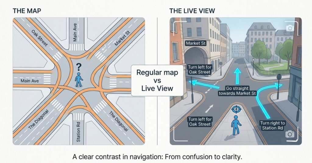
Live View is the AR navigation mode where you hold your camera up while walking and directional arrows appear overlaid on the actual street in front of you. It got a significant update in 2026, better landmark recognition and improved accuracy in dense urban areas, which is where I use it most.
The regular map view is fine when you’re driving. When you’re walking somewhere unfamiliar, especially somewhere where all the streets look similar or you can’t easily read the signage, the regular map is harder to use than it sounds because you keep having to figure out which direction you’re facing relative to the map. That mental translation from a top down view to the street you’re actually standing in is something most people don’t notice they’re doing until something like Live View removes it entirely. You just follow the arrows.
It also identifies things around you as you hold the camera up, ATMs, restaurants, parks, transit stops, with their hours, current busyness, and ratings visible without you searching for anything. I’ve used that specifically to find a cash point while walking somewhere and had it come up before I’d even finished thinking about where to look. I use Live View almost every time I’m navigating on foot somewhere I don’t know, and I genuinely don’t understand why it isn’t more widely used given how long it’s been there.
Battery is the catch. The camera being live the whole time drains it faster than regular navigation. For a ten minute walk it doesn’t matter. For longer stretches it’s worth watching your charge.
The Timeline
In the profile menu under “Your Timeline” there’s a full chronological record of everywhere you’ve been, places, routes, how long you spent at each location. It got accuracy improvements this year. I have a fairly specific relationship with this feature because my first reaction was that it was slightly unsettling to see it all laid out, and my second reaction was to actually find it useful.
I once needed to recommend a restaurant I would eaten at on a work trip about eight months earlier and had completely forgotten the name of. Timeline had it and the less obvious case is that looking at it occasionally shows you patterns in your own movement that you wouldn’t otherwise notice, the places you go to more than you thought, the detours that consistently add time to a commute.
The privacy thing is real and worth saying clearly, if you have location history enabled, Google has this data whether you look at it or not. Timeline just makes it visible to you rather than invisible. You can pause location history, delete specific periods, or turn it off completely from inside the Timeline settings. If you’re comfortable with the data existing, the Timeline actually does something useful with it. If you’re not comfortable with it existing at all, now you know where to turn it off.
If you’re using Maps to navigate to meetings and capturing notes afterward, pairing it with a solid note-taking app makes the workflow much more useful.
Map Layers
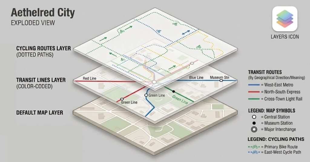
Most people never tap the stacked layers icon in the top right corner of the map. It shows satellite view, terrain, transit lines, live traffic, cycling routes, and in 2026 they added environmental and accessibility overlays including air quality data.
The transit layer is the most underused of all of them. Turn it on and you can see bus and train routes across the city laid out on the map in real time rather than just following a point to point direction that happens to use transit. If you’re trying to figure out how well connected a neighborhood is or which part of a city makes sense to stay in when you’re travelling, the transit layer shows you that in about ten seconds in a way that no amount of reading listings or Googling can quite replicate. I used it when I was trying to decide between two areas to stay in on a trip and it made the choice obvious because one of them had three lines running through it and the other had a bus that ran twice an hour.
The cycling layer is the other one worth knowing about specifically. It shows dedicated lanes, shared paths and rates surfaces by difficulty, which is genuinely different information from a walking or driving route. If you cycle at all, even occasionally, it’s worth turning on once just to see what the map looks like from that angle.
The air quality overlay is newer and I will be honest, I haven’t found a strong regular use for it personally. But if you have asthma or any reason to think about air quality in your area, it’s there and it draws on real time environmental data.
Measure Distance
Tap and hold anywhere on the map to drop a pin. Scroll up on the card that appears and there’s a “Measure distance” option. Add more points and it calculates straight line distances between them, not following roads, just direct across the map.
I found this completely by accident trying to do something else, and I’m not sure it would have occurred to me to go looking for it. It’s useful for hiking and trail planning, or for any situation where you need rough distances across terrain rather than along a route. It’s also just oddly satisfying once you know it’s there, I spent probably ten minutes measuring random things around the city the first time I found it.
Common Mistakes
The one that probably costs people the most is assuming what they see in the default settings is the best the app can do. Glanceable Directions, parking memory, offline map auto-update, none of these are turned on when you install the app. The things that would make Maps most useful day to day are sitting in settings unactivated, and nobody’s going to go find them unless they know to look. I went years without touching the navigation settings after the initial setup and I doubt I’m alone in that.
The Popular Times thing is another one worth flagging, relying on the bars to judge whether somewhere is busy right now when the bars are showing historical averages. That’s a different question from what you’re usually actually asking, which is whether it’s busy today at this moment, and the answer can be completely different. A place that’s usually quiet on Tuesday afternoons can be slammed the specific Tuesday you show up because something happened nearby.
And for anyone who travels: download your offline maps before you leave the hotel, not while standing at a junction with no signal trying to figure out which way to walk. The download takes a minute or two on Wi-Fi. The frustration of not having it takes considerably longer, and it tends to happen at the most inconvenient possible moment because that’s when you most need to look something up.
When You Will Actually Care About Any of This
The features that live in settings stay irrelevant until the specific moment they’d have helped. The parking pin is invisible until you’re doing laps of a car park at night trying to remember if you went left or right when you came in. Offline maps don’t matter until your signal drops at a junction abroad and you realise you have no idea which way to walk. Glanceable Directions is a nice idea until the third time you unlock your phone to check your ETA while driving and decide there has to be a better way, there is, you just didn’t know about it.
I don’t think there’s a single feature in this article that would take more than five minutes to set up. The gap isn’t capability, it’s knowing these things exist, and that gap tends to close right after the moment you most wish it had closed earlier.
Where to Start
If you open the app right now, the most useful ten minutes you could spend is going into Settings, then Navigation, and turning on Glanceable Directions. Then go to Offline Maps and download wherever you live or travel to most. That’s two things, takes almost no time, and covers the two features that are most likely to actually change how the app works for you day to day.
After that: the next time you’re about to go somewhere new, open the listing first and actually look at it. Check Popular Times, look for a live busyness indicator, scroll through any Inside View photos if there are any. It takes thirty seconds and regularly tells you something that would have saved you a wasted trip.
Comparison Table
| Feature | Where to Find It | What It Does | Worth Turning On? |
|---|---|---|---|
| Glanceable Directions | Settings > Navigation | ETA and next turn on lock screen while moving | Yes, do this now |
| Parking Memory | Tap blue dot after navigation ends | Drops a pin at your parking spot | Yes, especially away from home |
| Ask Maps | Search bar, type naturally | Natural language search powered by Gemini | Yes, if it’s in your region yet |
| Offline Maps | Profile > Offline Maps | Full navigation without data, auto updates on Wi-Fi | Yes for travel, useful anywhere |
| Live View AR | Walking directions, camera icon | AR arrows overlaid on real world view | Yes for walking in unfamiliar places |
| Popular Times / Live Estimate | Any place listing, scroll down | Historical busy times plus real time estimate on some listings | Yes, two seconds before you leave |
| Timeline | Profile > Your Timeline | Record of past locations and routes | Optional, depends on privacy comfort |
| Layer Controls | Stacked layers icon, top right of map | Transit, cycling, terrain, air quality views | Yes for cycling and transit users |
| Measure Distance | Tap and hold map to drop pin | Straight line distance between any points | Useful for outdoor planning |
FAQ
Final Thoughts
Most of this was already in the app. The 2026 updates, Ask Maps and the improved Live View, added genuinely new things, but the features I use most, Glanceable Directions, parking memory, the layer controls, were sitting there the whole time waiting to be turned on. That’s a slightly odd thing to say about an app I’ve been using for years but the settings menu is easy to open once, decide it’s fine and never look at again. Most people do exactly that.

Pingback: Google Keep vs Notion vs Apple Notes: Best Free Note-Taking App in 2026